- Vietnam Overview
- Main Cities in Vietnam
- Regions in Vietnam
- Other Cities in Vietnam
- Getting to Vietnam
- Getting Around Vietnam
- Language in Vietnam
- Education in Vietnam
- Vietnam Activities
- Vietnam Attractions
- Vietnam Money & Shopping
- Eating and Drinking in Vietnam
- Dress Code in Vietnam
- Gift Giving in Vietnam
- Public Behavior in Vietnam
- Art Performance
- Custom and Habits
Cao Bang Province
 The cool weather combines with many high mountains, beautiful sightseeing to form the convenient for relaxing tour and discovery tour
Geography
Cao Bang Province is located in the Far North - East, shares borders with China on the north and east, Bac Kan and Lang Son provinces on the south, and Ha Giang and Tuyen Quang provinces on the west. The topography is complicated so inter-transportation is limited.
Cao Bang is divided into: one town municipality (thị xã) Cao Bằng and 12 rural districts : Bảo Lạc District, Bảo Lâm District, Hạ Lang District, Hà Quảng District, Hòa An District, Nguyên Bình District, Phục Hòa District, Quảng Uyên District, Thạch An District, Thông Nông District, Trà Lĩnh District, and Trùng Khánh District, four precincts, 14 towns under districts and 181 communes
Tourism
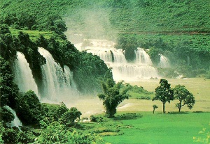
The cool weather combines with many high mountains, beautiful sightseeing to form the convenient for relaxing tour and discovery tour. Famous sites include Thang Hen Mountainous Lake in Tra Linh, Ban Gioc Fall and Nguom Ngao Cave in Trung Khanh. Among of them, Ban Gioc Fall probably is one of most beautiful waterfall in Vietnam. Several sites where Uncle Ho lived and worked before the August 1945 Revolution include Pac Bo, Coc Bo Cave, Lenin Stream, and Khuoi Nam Stream. In Cao Bang, the traditional festivals have specific characteristics of ethnic groups, for example, Long Tong Festival, Inviting the-Moon-Mother Festival (Moi Me Trang).

